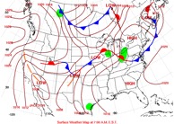
When comes to a weather map likes this, how to understand it? What’s behind each weather pattern?
Cold and Warm Front
A cold front usually brings rain and temperature drop. Cold fronts can move up to twice as fast and produce sharper weather changes than warm fronts, since cold air is denser than warm air. Cold fronts would also lift warmer air which cause the formation of a narrow line of showers and thunderstorms when moisture is present. This upward motion causes lowered pressure along the cold front.
A stationary front is the boundary between warm and cold air masses. Neither air mass is strong enough to move another. A stationary front can be pushed back and forth over a given area for days.
As warm air rises above the cold air in a warm front, water vapor condenses forming high clouds. Light precipitation can fall on areas as warm front passes. Air between a cold and a warm front is called a warm sector. When cold front catches up the warm front, it becomes an occluded front.
Warm front is easy to identify as the leading edge of high clouds approaching on the horrizon. It can leave clouds behind following by a cold front, which is hard to spot. Deep cloud layers form as the warm moist air is forced to rise and cool. These cloud layers produce lots of rain often in bands, which tend to be quite narrow with heavy rains and sometimes thunderstorms. When a cold front passes there is often a dramatic clearance with blue sky and sunshine. Temperatures fall at first but they may rise again when sunshine appears. This sunny weather doesn’t always last long because when cold air is warmed, it will rise or convect and produce shallow rain clouds.
Occluded Front
Occluded front is formed when a cold front overtakes a warm front, which is called cold occlusion. In a cold occlusion, the air mass overtaking the warm front is cooler than the cool air ahead of the warm front and plows upder both air masses; in a warm occlusion, the air mass overaking the warm front is warmer than the cold air ahead and rides over the colder air mass while lifting the warm air. Occluded fronts usually from around mature low pressure areas almost to the north where two fronts meet.
Trough and Ridge
A trough is an elongated region of relative low atmospheric pressure, ofen associated with fronts. In weather maps, a trough can be marked as a dashed line. Troughs can also be identified as an extension of isobars away from a low pressure center. Air usually rises to the east of the trough, favorable for the development of precipitation. The wind around a trough in the Northern Hemisphere will blow counterclockwise.
A ridge is the opposite of troughs. Air under a rige sinks which is not conducive for the development of precipitation. In the Northern Hemisphere, winds will blow clockwise around a high.
In general, troughs are behind low pressure areas while ridges are above high pressure areas in the NH. Low pressure system (marked as L) is usually related with rain, wind, and clouds.